Tag: gpslogger
Overview :
gpslogger II apps for blackberry
Model:
Blackberry 8350i (320*240) Related Devices Model: 8500, 8520, 8530, 9300(Kepler), 9330/Blackberry 83XX Series (320*240) Curve Devices Models: 8300, 8310, 8320, 8330 / Blackberry 87XX Series (320*240) Devices Models: 8700c, 8700r, 8700f, 8700g, 8703e, 8707, 8707g, 8707v .etc /Blackberry 88XX Series (320*240) Devices Models: 8800, 8820, 8830 .etc /Blackberry 89XX Curve Series (480*360): 8900(Javelin), 8910(Atlas), 8930, 8950, 8980/Blackberry 90XX Bold (Onyx) Series (480*320) Devices Models: 9000, 9020(Onyx)/Blackberry 96XX Tour (Niagara) Series (480*360):9600, 9630, 9650(Tour2), 9700(Bold2), 9780, Dakota, Apollo /Blackberry 95XX Storm Series (360*480):9500, 9510, 9520, 9530, 9550(Storm2), 9570(Storm3), 9800(Torch), 9810/9850/9860(Torch2)/Blackberry Pearl 3G Series (360*400) Devices Models: 9100, 9105, 9670(Style)/Blackberry 99XX (OS 7.0) Series (640*480) Devices Models: 9900, 9930
Description:
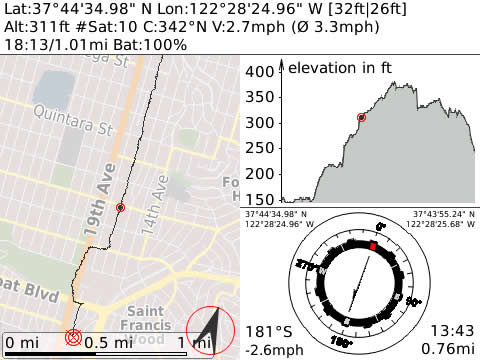
GPSLogger II is a pretty straightforward application – it records your physical movement on your BlackBerry® device over time. The recorded information includes, beside your actual location data in WGS84, the elevation, your speed and some additional data. You can select between imperial, metric or nautical units.
The location information can be displayed on a plain canvas or GPSLogger II can make use of BlackBerryMaps (if installed) to display your movement on a map. Please note when you make use of BlackBerry Maps that this can imply additional data charges.
Additionally, GPSLogger II can direct you to a location that you either entered manually or have previously recorded (via the "Guide Me Home" function). This can be quite useful whether you want to locate your car in a big parking lot or you are in the wilderness and have lost your orientation.
As extended functionality to the "Guide Me Home" feature a very easy to use outdoor navigation is integrated into GPSLogger II also. As latest addon you can use GPSLogger II also as LapTimer - a very powerful feature for all who need to keep track of intermediate timings.
The most important aspect of GPSLogger II is that it will work 100% offline - no data will be transferred while you use it (except when the BlackBerryMap view is used).
Core Features of GPSLogger II
•Record your movement over time - the following values will be stored:
?longitude / latitude
?accuracy for longitude & latitude values
?# of satellites
?current altitude (in WGS84)
?current course/heading
?current speed
?name of location (if specified)
•Display of the current data in various views:
?Path View: Displays the traveled path in a x/y coordinate system (2D-View)
?Elevation View: Displays the change of altitude over time
?Speed View: Displays the change of speed over time
?GPS View: Displays longitude, latitude, heading and speed in a large font (e.g. for your own navigation)
?Timing View: Displays elapsed time, current speed and Ø speed in a large font (e.g. for runners and cyclists)
?Compass View: Displays the current heading in a nice compass view
?Direction View: Shows an arrow/line that points into the direction of stored location (according to your current heading)
•Outdoor navigation (incl. ETA) -> see documentation for details
•"Guide me Home"-Function for people who easily loose orientation like myself ;-) (see 'Direction View')
To reach the destination you have stored, travel in the direction of the arrow on the device. If the arrow is pointing up, you are traveling in the correct direction to reach your selected destination. If the arrow is pointing down, you are traveling away from the selected destination. This makes GPSLogger II also suitable for Geocaching!
•Lap Timer functionality
•Zoom IN & Zoom OUT for path, elevation and speed views
•"Distance Alerts/Signal" - the device can peep & vibrate after a user-specified distance (in meters or feet) was traveled (especially useful for runners & bikers)
•Night Mode in 4 different colors (yellow, blue, red and green)
•Save current location to use it later with the "Guide me..."-Function
•Store current location on the Clipboard (e.g. to paste it into a SMS or eMail)
•Support for wildlife tracking/recording (with the option to select from predefined location names)
•Load and display a previously recorded path
•Summarize information about a previously recorded path
•Export recorded paths into CSV, GPX, KML (GoogleEarth) formats (and send it via email if you wish)
•Import a path in GPX or KML format (e.g. that are recorded with other applications that support GPX-Export or have been downloaded from websites like GPSies.com
|