Tag: aiSpot blackberry a
Overview :
aiSpot v2.4.15 for blackberry apps
Description:
aiSpot is a 2010 BlackBerry® Super Apps Challenge Regional Selection Winner!
NEW VERSION! Includes Map View , multi-touch support for all maps (for touch-capable devices). Supports Italian and Russian!
aiSpot significantly extends tracking capabilities of your phone. Use it to:
• record and export points (“Waypoints”)
• record tracks (“Tracks”)
• export tracks to a computer programs like Google Earth or to a compatiple GPS navigation device (“Tracks”)
• view the path being covered, destination point, and a compass face, overlaid on the map that is constantly self-aligned according to the movement (“Map ”)
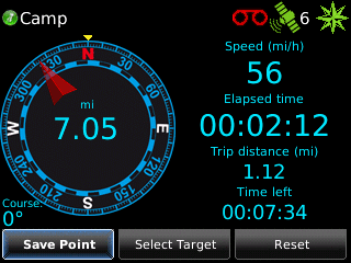
• Control the direction and 6 preset parameters on a compass dial (“Compass “)
• Control speed on an analog speedometer, preset speed limit and the sound alarm (“Speedometer”)
The aiSpot is fully compatible with BlackBerry® Maps. For example, you can select your destination on a map, send a link to a map with your current position indicated to your friends, or view a recorded GPS track overlaid on a map.
Find out why the aiSpot has a rating of a 2010 Super App Developer Challenge Regional Selection !
IMPORTANT:
• Google Maps support is LIMITED: only for viewing waypoints – not the tracks
• Verizon devices (except BlackBerry® Storm™) ARE NOT SUPPORTED due to carrier restrictions
computing over 13 parameters of the trip and displaying any 6 of them on the full tunable compass dashboard
view the path being covered, destination point, and a compass face, overlaid on the map that is constantly self-aligned according to the movement
large scale graded in degrees and points
displaying distance direction and time left to the target point
viewing current position on a map (supported Blackberry Maps and Google Maps)
storage of an unlimited number of points
different ways to input coordinates of waypoints: capture of the current coordinates, pick on a map, manual input and import from .gpx file
export waypoints to .gpx file
sending email with coordinates of the current location and target point (supported Blackberry Maps and Google Maps)
displaying the current speed on the analog and digital speedometer
displaying the average, maximum speed, distance and duration of the trip
customizable speed limit alarm
recording GPS tracks
aerial view of the GPS track
map overlay of the GPS track
speed / altitude profile of the GPS track
export GPS track in GPX format
export GPS track in KML format
support Autonomous and Assisted GPS modes
support US(English) / metric / nautical units
altitude adjustment
limited integration with Google Mobile Maps™
full integration with Blackberry Maps™
backlight control (prevent sleep)
battery control
Model:
Blackberry 82XX Series (240*320) Pearl Flip Devices Models: 8200, 8220, 8230/Blackberry 8350i (320*240) Related Devices Model: 8500, 8520, 8530, 9300(Kepler), 9330/Blackberry 83XX Series (320*240) Curve Devices Models: 8300, 8310, 8320, 8330 / Blackberry 87XX Series (320*240) Devices Models: 8700c, 8700r, 8700f, 8700g, 8703e, 8707, 8707g, 8707v .etc /Blackberry 88XX Series (320*240) Devices Models: 8800, 8820, 8830 .etc /Blackberry 89XX Curve Series (480*360): 8900(Javelin), 8910(Atlas), 8930, 8950, 8980/Blackberry 90XX Bold (Onyx) Series (480*320) Devices Models: 9000, 9020(Onyx)/Blackberry 96XX Tour (Niagara) Series (480*360):9600, 9630, 9650(Tour2), 9700(Bold2), 9780, Dakota, Apollo /Blackberry Pearl 3G Series (360*400) Devices Models: 9100, 9105, 9670(Style)
|